Iceland - Land of Fire and Ice (August 2018)
Iceland was a relatively recent quest for us after seeing
the videos of its unique landscape and hearing from some of our friends who
have visited recently. It was a really difficult choice to decide on what to
cover during our visit – Do we do try to drive along the coast (mostly) of the
entire island, like many do?! Do we select only a few spots and immerse in its
beauty?! In the end, we decided to do only some selective spots as we didn’t want
to strain ourselves too much in setting up some lofty goals like touring the
entire island. It’s a small piece of island, but still the span is too much to
drive around and still take a breather to enjoy each location. So, it turned to
be a good choice for us!
We read about renting a modem for wifi on the go. Apparently, any corner of Iceland seem to have relatively good connectivity, at least for mobile signals. When we arrived at the reception hall, the car rental companies were escorting scores of people to the rental location. The car rental guy confirmed that they can lend us a wifi modem - so, we didn't have to pay for a separate one from the airport vending machines. Another thing worth mentioning - The exchange rate for the Iceland Kroner at the airport was not so attractive. Moreover, whether any hard currency is needed is a of question, as almost all places in Iceland accept credit cards. We decided to move on without any local currency and it was not a bad decision.


 We continued further and stopped at a Búðir that provided for another photo op, especially under those cloudy dark skies.

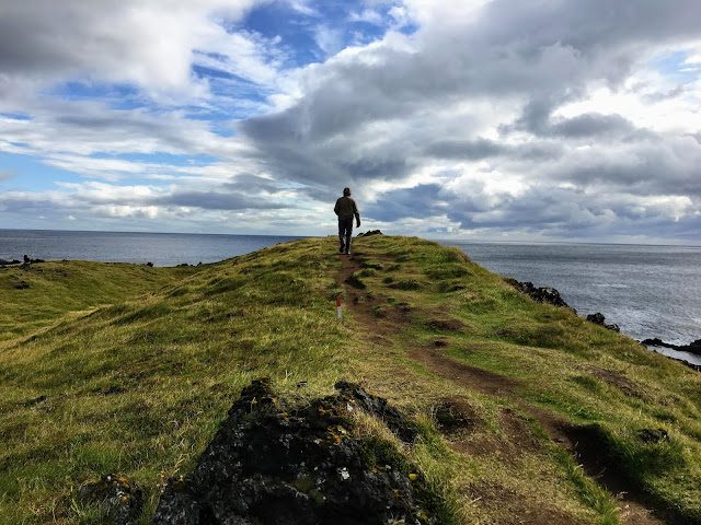
 Next place that is worth mentioning is the Arnarstapi where we
took a really long hike along the edges of land with ocean trying to hug the
bases vigorously. Rocky cliffs and basalt columns were lining those edges.
Luckily, the rain had taken a break and just when we got back to the car, it
started raining again and this time vigorously! Good setting for a lunch inside
the car. Arnarstapi is certainly
worth spending some time.
Next place that is worth mentioning is the Arnarstapi where we
took a really long hike along the edges of land with ocean trying to hug the
bases vigorously. Rocky cliffs and basalt columns were lining those edges.
Luckily, the rain had taken a break and just when we got back to the car, it
started raining again and this time vigorously! Good setting for a lunch inside
the car. Arnarstapi is certainly
worth spending some time.


 Gulfoss is the highlight in the Golden circle – the wide Hvítá
river makes huge span of the falls making it a spectacular spot. It is a
two-tier waterfall – the first one being so wide, falling into a large span of
river and the second from that, falling into a narrow gorge. Apparently, there
is a folk lore that a local settler Sigríður Tómasdóttir fought for protecting these
falls without building dams around it to harness its hydro-electric power.
Gulfoss is the highlight in the Golden circle – the wide Hvítá
river makes huge span of the falls making it a spectacular spot. It is a
two-tier waterfall – the first one being so wide, falling into a large span of
river and the second from that, falling into a narrow gorge. Apparently, there
is a folk lore that a local settler Sigríður Tómasdóttir fought for protecting these
falls without building dams around it to harness its hydro-electric power.


 We were supposed to visit the island of Vestmannaeyjar the next day. When we woke up, the weather was so bad that we really wished that they cancel the ferry to the island. It was wildly windy that would have made the ferry ride treacherous. When we checked the email in the morning, there was an email from them saying that all the ferries are cancelled for the day. The entire email was in Icelandic with a a few words towards the end, indicating a refund - so, we assumed the ferry was cancelled. We tried to ask the front desk in Skogafoss hotel, but apparently, nobody there knew Icelandic. Most people working in the service industry, apparently, come from eastern Europe. So, we just relaxed in the hotel which was needed with all the driving until that day.
Next stop was Sólheimajökull on Road 221 that went north from Route 1. Sólheimajökull is a part of the larger Mýrdalsjökull glacier which lies atop the Katla caldera. The glacier is melting rapidly owing to warmer annual temperatures due to climate change. It is possible that many of the country's glaciers will become extinct within the next century. Though the weather was cloudy, it brought out the amazing colors of the glacier and provided for a wonderful visual treat with the surrounding moss covered landscape.


 After spending some time devouring the pristine beauty of that view, we drove down and continued to Reynisfjara Black Sand Beach. It was still a cloudy day with a light drizzle, but the violent ocean with its huge waves made it even more scary.
 With its enormous basalt stacks, roaring Atlantic waves and stunning panoramas, Reynisfjara is widely considered to be the most beautiful example of Iceland’s black sand beaches. In 1991, National Geographic voted Reynisfjara as one of the Top 10 non-tropical beaches to visit on the planet. From here, you can get a visual of the Dyrhoaley from where we drove from. The clarity was just enough to get a visual of Dyrhoaley.
 Trolls! - From the beach, on the other side, there are some rock formations that were aptly named 'Trolls' :)
 The waves in this area were so wild that there are several warning signs. In spite of this, there have been occasional deaths of people ignoring those warnings. The waves do seem to sneak up from nowhere and come afar into the beach sands. The entire environment there was so apt for photographers, that we saw a shoot of some models in bright red attires.
 Fjaðrárgljúfur is another spectacular location that should not be missed. Fjaðrárgljúfur canyon was created by progressive erosion by flowing water from glaciers through the rocks over a long period of time, some say 9000 years ago. It was a sunny day with sun at an angle, giving us various different amazing views depending on which direction you see.
 The picture below is of a peculiar Drangshlíð Rock with a shaggy barn-like structure at its base, ideal for stories about elves :)

We wanted to go see the Svartifoss, but were worried about the forecast. As it hasn't started raining yet, we thought of making a quick dash to whatever distance possible on the hike to Svartifoss. To our luck, the cloudy day didn't bring any major rain until our reach to Svartifoss. Though it wasn't a huge falls, the surrounding dark lava columns, which gave rise to its name, provided a very unique appearance.

 Another glacier with a lagoon of floating ice-bergs at its bases is Fjallsárlón, The majestic Fjallsárlón is at the south end of the glacier Vatnajökull. On the lagoon, you can see floating icebergs that have calved from the edge of the glacier


 Another lagoon that is very popular and can be seen right from the highway is Jökulsárlón. On one side of the highway is the glacier and on the other side is the Atlantic Ocean. The melt of the glacier forms a lagoon and the lagoon flows into the ocean which is within a short distance. The icebergs floating on the lagoon slowly seem to be making their way into the ocean through that short river. It was great to witness these icebergs traveling at different speeds depending on their size, forming banks and creating traffic jams on their way to the ocean.


 Once the ice-bergs reach the ocean, some seem to float away, but some get thrown back to the shore by the violent waves of Atlantic, transforming the black sand beach into a beach of glistening ice-bergs. This beach is aptly named 'Diamond Beach'. It was quite an interesting location with so many ice-bergs traveling to the ocean and getting pushed back on to the adjacent beach sands.


Overall, the weather in Iceland changes lightning fast!
Reykjanes Peninsula
We arrived early morning in Reykjavik and couldn’t check
into the hotel until later in the day. So, decided to pay a visit to Reykjanes
peninsula where the intercontinental plates (Eurasia and North America) meet.
It was so humbling to see how a teeny tiny island has this continental divide
running through it, but when you consider the volcanic activities in Iceland,
it makes perfect geological sense that the island might itself have been formed
because of the continental plates colliding with each other. The Bridge between two continents is a small footbridge over a major fissure which provides clear evidence of the presence of a diverging plate margin.

There are series of craters and these crater series have been named Stampar. The crater series are from two periods. Walking up onto the crater was a different experience.

Eldey - A sheer 77 metre high rock protruding out of the sea. One of the biggest gannet colonies of the world is still surviving on Eldey

We also visited Reykjanesviti where ocean-water was crashing against rocky cliffs. The gorgeous view of the ocean water hitting the steep cliffs in a serene location was very peaceful to spend some time and have the lunch!


We saw a lot
of geothermal activity in Gunnaver not so far from here – A lot of
geysers spewing steam /hot water and boiling mud created by this
steam/hotwater. Right beside this is a geothermal power station harnessing the
thermal energy from this activity below. All over Iceland, there are a lot of
geothermal power stations and Iceland is 100% renewable energy island!

Brimketill is a small, naturally carved pool, by marine erosion, at the lava shore edge

How can
a place with so much natural hot springs not have a place for amusement of the
tourists? Of course, there is a super-expensive Blue Lagoon that caters for
this yearning where the pool is filled with natural hot spring water with
steaming braids of hot water streams around it, making it an exotic location
for the visitors. One interesting note that we read there was that the moss covering the lava rocks there were apparently flammable given the right conditions! We already had plans to visit a more economical location with
similar experience when we visit that a few days later. So, we just enjoyed the
view of blue lagoon, had a cup of super-expensive caffeine drink and moved on J.


Then we continued to Seltún Geothermal area and
made a hike that was taking us along a path that provided a spectacular view of
the lakes below and hot water springs beneath the hill. The hike was a little
scary in some places, but it was certainly worth it for the views it provided.


Landmannalaugar
We had booked a day trip to Landmannalaugar from Reykjavik.
The day turned out to be a great, weather-wise, with relatively good sunshine.
We started the day early and were accompanied by a few other tourists (totally
seven in the van) and on the way, we got a glimpse of the Eyjafjallajökull
volcano (that erupted in 2010) in a pit stop where we grabbed some Icelandic
yogurt that the locals call Skyr. It is technically not yogurt because of the
way it is made and the bacteria used to ferment it.
 On the way to Landmannalaugar,
we started seeing the wild horses of Iceland. With hills behind, the
free-roaming horses on the meadows provide for a spectacular photo op. The
driver started doing what is supposed to be a ‘7-minute’ stops, one of which involved
feeding the wild horses from behind a fence (of course).
On the way to Landmannalaugar,
we started seeing the wild horses of Iceland. With hills behind, the
free-roaming horses on the meadows provide for a spectacular photo op. The
driver started doing what is supposed to be a ‘7-minute’ stops, one of which involved
feeding the wild horses from behind a fence (of course).
During the rest of the trip, we saw so many horses in the wild. In the beginning, we thought they could wild horses, but as we learned, these horses are being raised all over Iceland for their meat! It was such majestic animals in an awesome landscape that we put a lid on that fact and just enjoyed the scenery. The same thing is with the all the Icelandic sheep that we saw all over - they are being raised for their wool and meat. But for these two herbivores, there are hardly any other carnivores in the wild in Iceland. So, campers in Iceland don't have to worry about any wild animals, but the wild weather is something to watch out for!


 We passed
through a lot of interesting landscapes with mountains in the background and
the centuries old lava field in the foreground. We saw many different
craters in a range of sizes. We did stop by some (mentioned later here).
We passed
through a lot of interesting landscapes with mountains in the background and
the centuries old lava field in the foreground. We saw many different
craters in a range of sizes. We did stop by some (mentioned later here).


 The
mountains hardly had any vegetation bigger than a bush. At the campground, many people camped there and venturing out into the hiking
trails around – it was all so open that anyone can see as far as the eyes can
see without any natural hindrance like a tree.
The
mountains hardly had any vegetation bigger than a bush. At the campground, many people camped there and venturing out into the hiking
trails around – it was all so open that anyone can see as far as the eyes can
see without any natural hindrance like a tree.
 We went on a hike that started
with a path along a brook formed by the melting ice/snow on the top of the
mountains.
We went on a hike that started
with a path along a brook formed by the melting ice/snow on the top of the
mountains.


 Then we continued on the hike through areas of
hot water geysers in the slopes and then on to a meadow of plants with flowers
blooming and mountains surrounding the meadow. Even on cloudy day like that,
the view was surreal.
Then we continued on the hike through areas of
hot water geysers in the slopes and then on to a meadow of plants with flowers
blooming and mountains surrounding the meadow. Even on cloudy day like that,
the view was surreal.


During the rest of the trip, we saw so many horses in the wild. In the beginning, we thought they could wild horses, but as we learned, these horses are being raised all over Iceland for their meat! It was such majestic animals in an awesome landscape that we put a lid on that fact and just enjoyed the scenery. The same thing is with the all the Icelandic sheep that we saw all over - they are being raised for their wool and meat. But for these two herbivores, there are hardly any other carnivores in the wild in Iceland. So, campers in Iceland don't have to worry about any wild animals, but the wild weather is something to watch out for!

Then, he made a stop
that had distant views of several mounts or volcanic origins. In the distance
was Hekla, the most active volcano of Iceland. This place also seemed
to be a place where flame retardant material was being mined from these
mountains. The material was so porous with what appeared to be stones were so
light and didn’t weigh anything like normal stones would. These are apparently mined and used as building material for their light weight and flame retardant properties.

The landscape that we were
passing through was a lot of lava fields (lava desert, as it is called) formed 1000's of years ago, that
have started seeing some vegetation growing in those fertile fields. The
vegetation was so primitive, but thriving with wild flowers, showing the
eagerness for these vegetation to take over the landscape rapidly. This combination
of light green vegetation with the black lava field in the background provides
for an interesting landscape. It looked like a landscape certainly from out of
this world – maybe Mars!


Then, we stopped at a spot, supposed to be a location
where they filmed a fight scene between Thor and Loki. In some areas, the van
had to cross shallow rivers, which made is very interesting to watch – all the
more reason that it is not a good idea to drive by yourself with a rental car!


The hills and mountains were so colorful from the different minerals
that were probably brought out by the lava from years ago. These colored
mountains are made of ‘rhyolite’ – a form of volcanic rock. It was supposed to
be an hour and a half of hike. We went through the fields of lava, climbing up
and down on those rocky structures with some sheep playing hide and seek into
those structures, making it a delight to the eye. In the middle of the lava
fields, we found a reasonably flat area to stop for lunch break. Lunch tasted
so much better in the ambiance.


Finally, by the time, we got back to the van, we
discovered that the van had some issues and had to spend additional 3 hours
before another van could come to pick us up. We used that time to walk through
a flat area of little streams of water running across in several streams from
the melting ice on the mountains that are surrounding that valley. Wow, what a
landscape, along the foothills of several hills one after another, with some
showing geyser activity. We had to jump across the little streams and find our
way around. Imagine that there would be a river running through there
in spring/early summer when the snow was actively melting.


We got into another
vehicle, which the guide Ragnar breezed through that rough terrain which only
can be done comfortably/safely with a 4-wheel drive with a higher base.We
stopped at a huge crater filled with water in the deep crevice (Ljótipollur)
for another photo op and continued on to see a waterfalls (Hjálparfoss) as the
last stop before returning to the hotel. Hjálparfoss was a twin fall falling
into a pool of water all along the path of a river.


Reykjavik
In Reykjavik, we wanted to visit the famous Hallgrímskirkja church
and the Harpa music hall in the city. It started with the typical rainy/windy
weather. We were initially disappointed before getting used to the new norm of
weather patterns in Iceland! The façade of the church was so contemporary that
made is a super attractive photo spot. It didn’t matter that is was windy or
rainy or cloudy. The artistic music hall
building was another spot known for its modern architectural construction.


Western region (Snæfellsnes Peninsula)
The drive that took us through the landscapes looked so different and new to us from what we have seen in the day before. We passed through huge rivers and drove along the mountainous road. We took a longer route by avoiding a tunnel to soak in a different landscape and it was so worth it. We went through the town Borgarnes where we stopped at the local Bonus grocery store to fill up and get a coffee in the adjacent Bakari. It was very cloudy and drizzling all along the way and by the time we reached the Guesthouse Hof, it was dusk. We settled down in that cozy place.

 The next
morning, we started our drive and made the first stop at Rauðfeldsgjá Gorge. It
was a hidden canyon that is very narrow to enter with a stream of water flowing
out from a big block of ice stuck in the gorge – maybe, it can be called a
‘mini’ glacier!
The next
morning, we started our drive and made the first stop at Rauðfeldsgjá Gorge. It
was a hidden canyon that is very narrow to enter with a stream of water flowing
out from a big block of ice stuck in the gorge – maybe, it can be called a
‘mini’ glacier!


Then we continued onto Lóndrangar basalt cliffs with
more ocean hugging cliffs, followed by a stop at Vatnshellir cave. We took a
tour of the cave formed by lava which is called a ‘lave tube’.


Another spot is Djúpalónssandur Black Beach – from a
distance, it appears as if it is a black sand beach, but when you take a closer
look, and you can see the black pebbles of different sizes. Eventually, after
several hundred years these marbles would eventually become sand, constituting
a black sand beach (I guess!).


Kirkjufell Mountain is a very interesting one that appear to
change its shape as you drive from far to close because of the shape of it like
a trapezoid with a peak on the top. A nearby waterfall provides for a wonderful
foreground with the Kirkjufell in the background. Many photos for these can be
found all over the web, making this a popular spot to stop by.


Golden Circle
From the west region, we took the short-cut through the
tunnel (Hvalfjordur Tunnel) to get to the Golden circle and then to continue
onto the south. Golden circle is a popular spot that many tourists tend to
complete in just a day during a brief stop-over between NA and EU. The main
area here is Þingvellir National Park where there is a waterfalls Öxarárfoss and
large flat-land with streams of rivers flowing between green meadows. Þingvellir lake is the largest lake in Iceland. Apparently, this is where the first parliamentary proceedings of Iceland was held, as far back as 930AD.


 A stop at
the Efstidalur Farm for ice cream can be a good break for a great locally made
ice-cream. Then, another spot in the Golden circle is the Geysir geothermal
area where there are couple of fountain geysers – Strokkur is the most reliable
one that erupts periodically and almost nobody can miss it. This area also has
boiling mud pits and streams of boiling water flowing through.
A stop at
the Efstidalur Farm for ice cream can be a good break for a great locally made
ice-cream. Then, another spot in the Golden circle is the Geysir geothermal
area where there are couple of fountain geysers – Strokkur is the most reliable
one that erupts periodically and almost nobody can miss it. This area also has
boiling mud pits and streams of boiling water flowing through.


Before heading the hotel, a stop at the Secret Lagoon made it a relaxing event, especially the geothermal pool there. Secret lagoon is much more affordable than the Blue Lagoon in the Reykjanes peninsula.

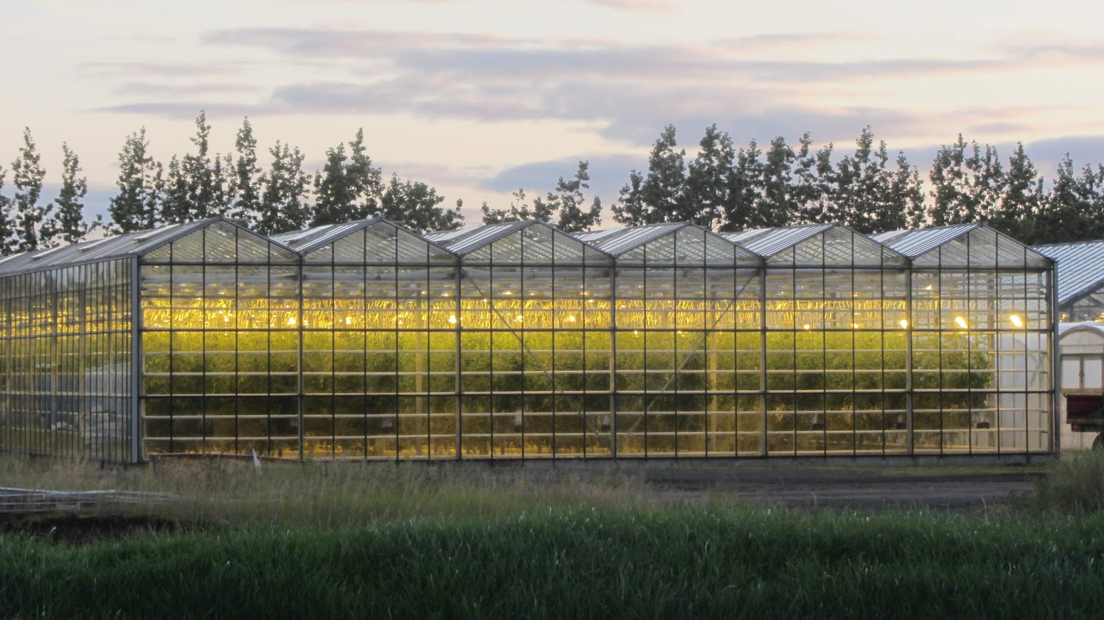
Although Iceland is reliant upon fishing, tourism and aluminium production as the mainstays of its economy, the production of vegetables and fruit in greenhouses is a growing sector.
Then, we passed through Kerið crater that is known for its
blue colored water. A hike around the crater is a popular activity for many
visitors.

South Coast
We started the south coast drive by making a brief stop at
the Ægissíðufoss water falls. Not many visitors were there and it was a bit
tucked away on a small road off Hella when you go down the Ring Road, but provided
for a beautiful view.


 The parking near Seljalandsfoss can get
pretty crowded at times. So, parking at Gljúfrabúi, visiting that hidden falls
and walking to Seljalandsfoss seemed like a good idea. Walking up to Seljalandsfoss
and behind the falls was a wonderful experience, especially when it is sunny.
We luckily had a brief sunny weather that made it for a nice visit.
The parking near Seljalandsfoss can get
pretty crowded at times. So, parking at Gljúfrabúi, visiting that hidden falls
and walking to Seljalandsfoss seemed like a good idea. Walking up to Seljalandsfoss
and behind the falls was a wonderful experience, especially when it is sunny.
We luckily had a brief sunny weather that made it for a nice visit.
 Skogafoss, not that far from Seljalandsfoss, is a spectacular one, near which we stayed for couple days. Skogafoss area has a few different options to stay ranging from a guest house with shared bathrooms to a typical boarding with private bathrooms.
 By the side of the Skogafoss, there are stairs that can take one to get a view from the top of the falls. It was a pretty steep climb. Once at the top, you can also continue the hike. This hike is not so steep, but eventually, would lead to the glacier from which the Skogafoss river is flowing from. But, on the day that we went, it was very rainy and windy that we didn't continue for long on the hike.


Continuing on Ring Road, we made another stop at Gljúfrabúi –
this is a small waterfall that is hidden inside a rocky structure in front of
it. We have to navigate a little bit on the stream of water flowing from the
falls to get the beautiful view of the falls from a small chamber inside. Gljúfrabúi
is just a bit north of Seljalandsfoss.


We saw several groups being guided on glacier hikes. The visual of their hikes from a distance showed the contrasting size of the glacier field there.

Our next destination was Dyrhólaey. While most of the drive was on paved road, suddenly the road became unpaved at one point and started climbing. It was totally unexpected and the road got steeper and curvier, making it a quite interesting ride up to the place where the lighthouse was and a view of the vast span of the Atlantic from up there.


Another spot that is interesting to mention is Laufskálavarða on Route 1. In the old days traditionally everybody passing by Laufskálavarða for the first time added a stone to a cairn at Laufskálavarða for good fortune on their journey through this dangerous area. These stone cairns have piled up for the past millennia.


The drive to reach Vatnajökull National Park was quite a bit with a lot of interesting and changing landscapes along the way. As we get closer, we saw the massive span of glaciers in the horizon, giving us an idea on how far north of equator we have been driving. To get a view of the glaciers, one does not have to climb to any heights. Vatnajökull is defined by massive glaciers, ice caves, snowy mountain peaks, active geothermal areas and rivers. Once we reached the park office, it was late afternoon and the park officials mentioned that there is going to be rain later that day and the forecast for next day wasn't going to be any better.
We wanted to go see the Svartifoss, but were worried about the forecast. As it hasn't started raining yet, we thought of making a quick dash to whatever distance possible on the hike to Svartifoss. To our luck, the cloudy day didn't bring any major rain until our reach to Svartifoss. Though it wasn't a huge falls, the surrounding dark lava columns, which gave rise to its name, provided a very unique appearance.

The hike to Svartifoss was all through paved pathways, but the steepness in many areas made it a moderately difficult hike. After the hike, we came back to the base and it was still a cloudy day, with occasional drizzle. So, we decided to visit Skaftafellsjökull which is a much shorter hike without any climb. Skaftafellsjökull is a glacier tongue spurting off from Iceland's largest ice cap, Vatnajökull. It is one of many tongues stretching from the largest glacier in Europe, Vatnajökull itself. This ice cap covered eleven percent of the surface area of Iceland.


Another glacier that was easily accessible from Route 1 is Kvíárjökull which melts into the Kvíá river. We visited this glacier and the small lagoon on a relatively clear day and there were hardly 3-4 people, making it a serene, secluded location for a nice calm atmosphere where one could relax in the company of this majestic glacier for a while.


There were tour operators taking people on boats/dinghies in the lagoon to see the ice-bergs up-close.


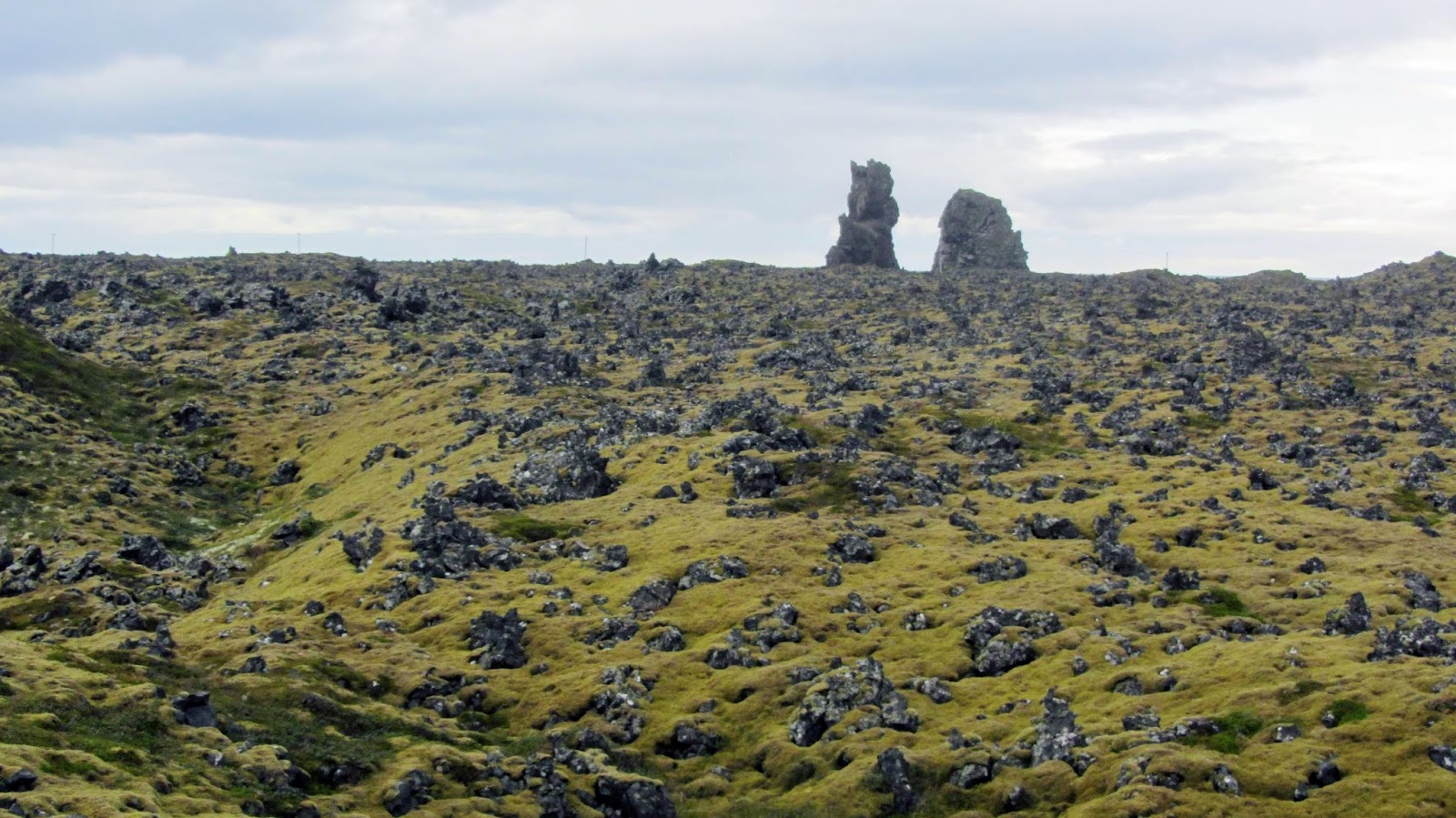
Landscapes of Iceland
Some random pictures are posted below just to share how varied and beautiful the landscape is in Iceland. Everywhere around, there are waterfalls, amounting to 1000s of them all across the island, varying from teeny tiny trickling ones to massive ones like Gullfoss.


Iceland…. Unique in its own amazing sense!


Comments
Post a Comment